Buying guide
GPS Watch vs Handheld GPS vs Phone: Choosing the Right Navigation Tool for Your Trip
Disclosure: Four Seasons Gear is reader-supported. When you buy through links on our site, we may earn an affiliate commission at no extra cost to you. Prices and availability are accurate as of the time we last checked.
What You're Really Deciding
All three options—GPS watches, handheld GPS units, and smartphones with GPS—can track your location and guide you along a route. The meaningful differences lie in three dimensions: battery endurance (hours vs. days vs. weeks), screen real estate for map reading (0.5–1.3 inches diagonal vs. 2.6–3.5 inches vs. 5–7 inches), and operational convenience (always on your wrist vs. stowed in a pack pocket vs. already in your pocket). A GPS watch excels at continuous tracking during activity without breaking stride. A handheld GPS offers the best balance of battery life, dedicated buttons for gloved use, and map detail for route-finding. A phone provides the largest screen and most versatile software, but burns through battery fastest and requires the most protective care.
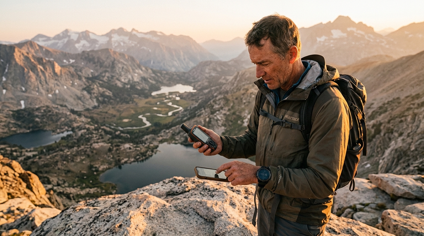
GPS Watch: Continuous Tracking Without Stopping
GPS watches integrate positioning with fitness metrics—heart rate, elevation gain, pace—on a screen you check mid-stride. Modern outdoor GPS watches like the Garmin Instinct 2 Solar GPS Watch run 28–48 hours in GPS mode, or indefinitely in smartwatch mode with solar assist under adequate sun exposure. The Garmin Fenix 7X Sapphire Solar Smartwatch Solar Charging Rugged Outdoor Watch with GPS Touchscreen pushes that to 89 hours in GPS mode with a larger battery and solar panel.
Specs
The small screen limits map reading—you see your track line and waypoints, but detailed terrain analysis requires zooming and panning with tiny buttons or a touchscreen that's awkward with gloves. GPS watches shine during continuous movement: trail running, bikepacking, alpine climbs where you need pace and elevation data without pulling out a device. They're less useful for complex off-trail navigation where you need to study contour lines or compare multiple route options.
Handheld GPS: Purpose-Built for Backcountry Navigation
Handheld GPS units like the Garmin GPSMAP 67 Handheld GPS prioritize battery life, physical buttons for gloved operation, and screens optimized for sunlight readability. They run on AA batteries (18 hours typical) or internal rechargeable cells (up to 180 hours in expedition mode with reduced GPS ping rate), and display detailed topographic maps on 2.6–3.5 inch transflective color screens.
Specs
The key advantage is battery swappability and longevity. Carry four AA lithium batteries (28 g total) and you have 72+ hours of runtime—enough for a week-long trek. Handhelds also offer physical joysticks or D-pads, which are vastly easier to operate with gloves or cold fingers than touchscreens. The dedicated form factor means no distracting notifications, no temptation to check email, and no risk of draining your communication device.
Handhelds are the right choice for multi-day backcountry trips where navigation is primary, especially in winter or shoulder seasons where touchscreen phones struggle. They're overkill for maintained trails where you're mostly tracking mileage, and they're redundant bulk if you're already carrying a phone with offline maps.
Smartphone with GPS: Maximum Screen, Minimum Battery
Modern smartphones contain full GNSS receivers (GPS, GLONASS, Galileo, BeiDou) and run sophisticated mapping apps like Gaia GPS, CalTopo, or Avenza Maps with offline topo map downloads. A 6-inch phone screen shows 8–10× the map area of a GPS watch and twice that of a handheld GPS, making it easier to see terrain context and plan routes on the fly.
Specs
The battery constraint is real. Continuous GPS tracking with screen-on navigation drains a phone in 6–8 hours. You can extend this by toggling airplane mode (GPS still works; cellular radios are the power hog), dimming the screen, and using a 10,000–20,000 mAh external battery pack (adds 180–360 g). In practice, most day hikers use their phone intermittently—check position every 30 minutes, screen off otherwise—and finish with 40–60% battery.
Phones excel for day trips and front-country use where you have nightly charging access. They're also the best tool for route planning at camp—large screen, full app ecosystem, easy waypoint entry. But they're a poor choice as your sole navigation device on multi-day trips unless you carry substantial battery backup and protective cases, at which point you're approaching the weight of a dedicated handheld.
Key Specs and What They Mean
Multi-GNSS Support
All modern devices support multiple satellite constellations: GPS (US), GLONASS (Russia), Galileo (EU), and sometimes BeiDou (China). More constellations mean faster satellite lock and better accuracy in canyons or under tree cover. Expect 10–20 satellites visible simultaneously with multi-GNSS vs. 6–10 with GPS alone. Positional accuracy improves from ±5 m to ±3 m under challenging conditions. This matters most in narrow valleys or dense forest; it's negligible on open ridges.
Track Logging Interval
GPS devices record your position at intervals: every 1 second (smart recording), every 5–10 seconds (normal), or every 30–60 seconds (UltraTrac/expedition mode). Shorter intervals produce smoother tracks and more accurate distance/elevation measurements but drain battery faster. For trail hiking, 10-second intervals are fine. For technical climbing or mountain biking where you're changing direction frequently, 1-second smart recording captures the route accurately. Expedition modes that ping every 60 seconds extend battery 2–3× but produce jagged tracks unsuitable for analyzing route details.
Barometric Altimeter
GPS-derived elevation is accurate to ±10–15 m vertically—worse than horizontal accuracy due to satellite geometry. A barometric altimeter measures air pressure changes and calculates elevation to ±3 m after calibration at a known point. All serious GPS watches and handhelds include barometers; phones mostly don't (exceptions: some Samsung and Google Pixel models). If you care about accurate elevation gain stats or want to use elevation as a navigation cross-check, barometric altimetry is essential. It also enables weather trend monitoring—falling pressure indicates incoming storms.
Screen Type and Readability
Transflective LCD screens (used in Garmin handhelds and outdoor watches) reflect ambient light, becoming more readable in bright sun—the opposite of phone OLED screens that wash out. Transflective displays are also visible with the backlight off, saving battery. OLED phone screens offer vastly better color and contrast in shade or indoors but require high brightness outdoors, accelerating battery drain. If you navigate primarily in full sun, transflective wins. If you're in forest or navigating at dawn/dusk, OLED's superior contrast helps.
Touchscreen vs Physical Buttons
Touchscreens are intuitive and fast for pinch-zoom map navigation. Physical buttons are operable with gloves, in rain, and with cold-numbed fingers. Many modern GPS watches (Fenix 7X, Instinct 2) offer both—touchscreen for maps, buttons for menu navigation. Handheld GPS units typically use button-only interfaces optimized for one-handed operation. Phones are touchscreen-only; capacitive gloves help but are imperfect in wet or freezing conditions.
Match the Tool to Your Trip
Here's how to pick based on trip type and priorities:
- Day hikes on marked trails (under 8 hours): Phone with offline maps. You're checking position occasionally, not navigating continuously. Battery lasts the day. Bonus: you already carry it.
- Trail running or fastpacking: GPS watch. You need continuous tracking without stopping, plus pace and heart rate data. The Garmin Instinct 2 Solar GPS Watch offers 48-hour GPS battery and wrist-based convenience.
- Weekend backpacking (2–3 days, established trails): Phone + small battery pack, or GPS watch. If you're confident with phone navigation and carry a 10,000 mAh pack for evening charging, phone works. If you want set-it-and-forget-it reliability, a GPS watch eliminates charging hassles.
- Multi-day backcountry (4+ days, off-trail): Handheld GPS with AA batteries. The Garmin GPSMAP 67 Handheld GPS runs 18 hours per charge, and four spare AA lithiums give you 90+ hours total—ample for a week. Larger screen helps with route planning at camp.
- Winter or alpine mountaineering: Handheld GPS or GPS watch (not phone). Cold kills phone batteries and touchscreens. Handhelds with AA lithiums work reliably to -20°C. GPS watches stay warm against your wrist under a jacket sleeve.
- Bikepacking or paddling: GPS watch or phone in waterproof case. You want glanceable navigation without stopping. Watches mount to handlebars; phones mount in waterproof cases. Handhelds are awkward to stow and retrieve while moving.
- International trekking (Patagonia, Himalayas): Handheld GPS + phone. Handheld for primary navigation and battery endurance; phone for detailed route planning, photos, and emergency communication (with local SIM). Consider pairing with the Garmin inReach Mini 2 Satellite Communicator for two-way texting beyond cell coverage.
The Hybrid Approach: Combining Devices
Many experienced backcountry travelers carry two devices for redundancy and complementary strengths. Common pairings:
- GPS watch + phone: Watch for continuous tracking and fitness metrics during the day; phone for detailed map study at camp and emergency communication. Total weight: 190–330 g. This is the most popular setup for multi-day trips.
- Handheld GPS + phone: Handheld for primary navigation and battery endurance; phone as backup and for route planning. Keep phone in airplane mode except when needed. Total weight: 300–500 g.
- GPS watch + handheld GPS: Overkill for most users, but justified for expeditions or professional guiding where navigation failure isn't acceptable. Watch for activity tracking; handheld for detailed map work. Total weight: 190–350 g.
The key is defining primary vs. backup roles. Don't run both devices in GPS mode simultaneously—it's redundant battery drain. Use one actively; keep the other as insurance.
Software and Map Ecosystems
Device hardware is only half the equation. Map quality and software features vary significantly:
Garmin handhelds and watches use Garmin's TopoActive maps (preloaded) with routable roads and trails. You can also sideload custom maps from OpenStreetMap or purchase Garmin's premium topo bundles. The Garmin ecosystem is closed but polished—maps sync across devices via Garmin Connect.
Phones offer the widest software choice: Gaia GPS (subscription $40/year, excellent offline topo and satellite layers), CalTopo (free online, $30/year for app), Avenza Maps (free for basic use, pay-per-map for specialized charts), and AllTrails (crowdsourced trail data, $36/year). These apps often provide better map customization—you can overlay snow cover, fire perimeters, land ownership—than Garmin's fixed layers.
For serious backcountry use, invest time learning one ecosystem deeply rather than casually using multiple apps. Know how to download offline maps, create waypoints, and export GPX tracks before you're in the field.
Battery Management Strategies
Extending runtime in the field:
- GPS watches: Enable solar charging (if equipped) by keeping the watch face exposed during breaks. Switch to UltraTrac mode (60-second ping interval) for non-critical tracking days. Disable smartwatch features (notifications, Bluetooth) in the backcountry to extend battery 20–30%.
- Handheld GPS: Carry lithium AA batteries (they weigh 30% less than alkaline and perform better in cold). Reduce screen brightness to 50% in daylight—transflective screens are readable without backlight. Enable auto-off after 2 minutes of inactivity.
- Phones: Airplane mode is mandatory for multi-hour GPS use. Disable background app refresh, reduce screen brightness, and use dark mode (OLED screens draw less power with black pixels). A 10,000 mAh battery pack (180 g) provides 2–3 full phone recharges. For week-long trips, a 20,000 mAh pack (360 g) or solar panel (200–400 g, weather-dependent) becomes necessary.
In cold conditions, keep lithium-ion devices (phones, rechargeable GPS units) in an inside jacket pocket when not in use. Body heat prevents capacity loss. AA lithium batteries in handhelds are less affected and can stay in the device.
Durability and Weather Resistance
GPS watches and handhelds are purpose-built for outdoor abuse. Watches meet MIL-STD-810 shock and thermal standards; handhelds use rubberized cases and recessed screens. Both handle rain, drops onto rock, and pack compression without issue.
Phones require more care. Flagship models with IP67/IP68 ratings survive brief submersion, but cracked screens are common after drops. A rugged case (adds 50–100 g) is essential for backcountry use. Even then, phones are more fragile than dedicated GPS devices—I've seen shattered screens after 1-meter drops onto talus that wouldn't faze a Garmin.
If your trip involves scrambling, bushwhacking, or high consequence of device failure (solo travel, winter conditions, complex off-trail navigation), the durability advantage of a GPS watch or handheld is worth considering.
Cost Analysis
Total cost of ownership over three years:
Specs
If you already own a capable smartphone, the incremental cost of using it for navigation is under $250 over three years—hard to beat. But if you're buying a device specifically for backcountry navigation, a mid-range GPS watch or handheld GPS offers better battery life and durability for similar money.
When to Upgrade or Add a Second Device
Start with what you have. If you own a smartphone, download Gaia GPS or CalTopo, practice on day hikes, and see if battery life and durability meet your needs. Most weekend backpackers never need more.
Consider a GPS watch when you start doing activities where continuous tracking matters—trail running, fastpacking, long alpine days—or when you want fitness metrics integrated with navigation. The Garmin Instinct 2 Solar GPS Watch hits the sweet spot of battery life, durability, and price for most users.
Consider a handheld GPS when trips extend beyond 3–4 days, when you're navigating off-trail regularly, or when you need bombproof reliability in harsh conditions. The Garmin GPSMAP 67 Handheld GPS is the current benchmark for backcountry handhelds.
Add a satellite communicator like the Garmin inReach Mini 2 Satellite Communicator when you're traveling beyond cell coverage and want two-way emergency communication. It's a separate decision from navigation—inReach provides basic GPS tracking but isn't a replacement for a watch or handheld for map-based navigation.
+Can I use my phone's GPS without cell service or Wi-Fi?
Yes. GPS is a receive-only system—your phone calculates position from satellite signals without needing to transmit or connect to any network. Download offline maps before your trip (Gaia GPS, CalTopo, Avenza, or Google Maps offline areas), enable airplane mode to save battery, and your phone navigates fine in areas with zero cell coverage. The limitation is that you can't download new maps or get live weather updates without connectivity, so plan ahead.
+How much does GPS drain my phone battery compared to normal use?
Active GPS tracking with the screen on intermittently drains most phones in 6–8 hours—roughly 12–15% per hour. For comparison, normal mixed use (messaging, browsing, photos) drains 8–12% per hour. The GPS chip itself uses only 2–3% per hour; the screen and processor are the real power hogs. Maximize battery by using airplane mode (disables cellular radio, saves 3–5% per hour), dimming the screen, and checking your position every 20–30 minutes rather than leaving the map open continuously. With these practices, most phones last a full day hike with 30–40% battery remaining.
+Do I need to pay for a GPS watch subscription or map updates?
No subscription is required for basic GPS functionality on any watch or handheld. Garmin devices include preloaded TopoActive maps that never expire. However, some advanced features require subscriptions: Garmin's premium map bundles (BirdsEye satellite imagery) cost $30–$50/year, and smartwatch features like music streaming or incident detection may require Garmin Connect premium ($10/month). For phones, apps like Gaia GPS and CalTopo charge $30–$40/year for offline map downloads and premium layers, though free tiers exist with limited functionality. Budget $0–$50/year for maps depending on your platform and needs.
+What's the accuracy difference between a $300 GPS watch and a $700 one?
Positional accuracy is nearly identical—both use the same multi-GNSS chipsets and achieve ±3–5 m under open sky. The price difference buys you longer battery life (48 hours vs. 89 hours in GPS mode), larger/better screens (1.2-inch vs. 1.4-inch, higher resolution), more durable materials (sapphire crystal vs. Gorilla Glass), additional sensors (barometric altimeter, compass, pulse oximeter), and premium features like preloaded ski maps or golf courses. For pure navigation accuracy, a $300 watch performs equivalently to a $700 one. You're paying for endurance, build quality, and feature breadth.
+Can I navigate with a GPS watch if I've never used one before?
Yes, but expect a learning curve. GPS watches are less intuitive than phone apps—small screens and button-based menus take practice. Start by loading a GPX track (exported from a mapping app or downloaded from a trail database) onto the watch via Garmin Connect or similar software. On the trail, the watch displays a breadcrumb line showing the route and a pointer indicating direction to the next waypoint. You won't see detailed topo maps on most watches (premium models like the Fenix 7X show basic maps), so you're following a line rather than reading terrain. Practice on familiar trails before relying on a watch in complex terrain. Pair it with a phone or paper map for the first few trips until you're comfortable with the interface.
+Should I bring a paper map as backup if I'm using electronic GPS?
For day hikes in familiar terrain, electronic GPS alone is fine—failure risk is low and consequences are minor. For multi-day trips, off-trail travel, or winter conditions, carry a paper topo map and compass as backup. Paper weighs 40–80 g, costs $10–$15, never runs out of battery, and works when your GPS takes a swim or shatters on rock. You don't need to navigate by map and compass primarily—use GPS as your main tool—but having paper backup provides insurance against the 1% scenario where electronics fail. Learn basic map and compass skills (triangulation, declination adjustment, terrain association) before you need them in an emergency.
+How do I know if my phone is accurate enough for backcountry navigation?
Test it. On a clear day, open your GPS app and check the reported accuracy (usually displayed as a circle or number in meters). Under open sky, you should see ±3–5 m. In forest or canyons, ±8–12 m is typical. If your phone consistently reports ±20+ m or loses GPS lock frequently, it may have a weak antenna or outdated chipset—consider upgrading or using a dedicated GPS device. Also test battery drain: track a 4-hour hike with your screen on intermittently and see how much battery you use. If you burn through 60%+ in 4 hours, you'll need an external battery pack for longer trips. Most phones from the last 3–4 years (2020+) have adequate GPS performance for backcountry use.